
Hiking across the Annapurna Range to the remote Tibetan villages and monasteries of Upper Manang
TREK REPORT APRIL/MAY 2008:
I have to admit that this trek surpassed even my own high expectations. I’ve long desired to visit the remote Tibetan valleys of Naar and Phu located in the upper reaches of Nepal’s Manang District. My goal this spring was to travel with a small group and research a trekking route that would give the adventurous soul the opportunity to experience all of what I feel makes Nepal so very special and keeps many of us coming back for more – big mountain views, high pass crossings, remote trekking, some not so remote trekking and a rich helping of the Hindu and Buddhist cultures. This trek has it all.
Our trip began with a 7 hour drive in a private coach from Kathmandu westward across the lowland countryside to the bustling town of Besisahar. Nowadays you can drive a further 45 minutes or so on a rough dirt road to the village of Bhulbhule, which sits along the mighty Marshyangdi River. One of the great attractions of the Annapurna area is the fact that most treks start at a low elevation and gradually ascend. At 2,625 feet/800 meters, Bhulbhule Village makes for an excellent jumping off point to begin the acclimatization process. Over the next three days we gradually ascended the Marshyangdi River valley camping at the villages of Syange, Tal and Koto respectively. These were wonderful days to wander through villages as the locals were bustling about getting the fields ready for planting. On an autumn trek, we would see villagers busily harvesting the rice, wheat and vegetables our group witnessed them planting. In the middle hills of rural Nepal, daily life consists of a beautifully orchestrated list of chores in which all family members play a role. Upon reaching Koto at 8,660 feet, we truly had the sense that we were about to enter a very special place. Koto is the eastern gateway into Upper Manang. Ninety-nine percent of all trekkers camped here tonight will continue west on the main Annapurna trail tomorrow. In the morning, however, our small group is the fortunate 1% that will be heading north into the narrow canyon with huge sheer rock walls that we can see from the campsite. It looks as though we will be walking into a Lord of the Rings movie! We are all very excited.
The Naar Phu region is the most remote of the Manang District and access is granted only with the purchase of a special permit. This area consists of two main villages – Naar with 300 permanent residents called Naar-ten and Phu with 200 permanent residents called Phu-ten. These remote villages are situated above treeline and completely cut off during the snowy winter months. Residents of these valleys make their livelihood mainly from herding yak and trading meat, wool and hides with the villages located in the lower regions of Manang. On this trek, we first make our way to Phu Village which is located in the northernmost corner of Upper Manang and only two days walk from Tibet. It takes four days of trekking to reach this remote community. En route we camped at the non-permanent winter settlements of Dharamsala, Meta and Kyang before finally crossing through the Phu Gate and arriving at this impressive walled citadel. We felt as if we had truly stumbled upon a lost civilization. Settled around the 10th Century by Tibetan herders and traders migrating south from Tibet, the inhabitants of Phu (also noted on maps as Phoo) once placed high value on their remote and strategic location. Tall stone lookout towers, now standing in ruins, where used to spot possible invaders coming from all directions and thick wooden doors where bolted shut at night locking the residents securely inside. We had the entire next day to explore this fascinating area. After a well appreciated late bed tea, our day was spent wandering around the village, visiting with the local school master who teaches 25 of the village’s children and had the great pleasure of sightseeing inside the Tashi Lakhang Monastery, which sits high above the village. Tashi Lakhang – ‘the blessed house of gods’ is one of the oldest monasteries (or gompas) in Manang. The gompa is one of 108 constructed by Lama Urgen Lhundup Gyatso and, along with the monastery in Braga, makes up the heart of spiritual life in the Manang District.
It takes two days to reach Naar, the principal and seemingly more prosperous village in these remote valleys. Naar, situated at 13,730 feet, is also called Chuprong meaning ‘the place of Blue Sheep’. The original inhabitants of this valley are believed to be from Tibet’s ancient Shang Sung Kingdom arriving sometime in the 8th Century and converted from Bon to Buddhism after the birth of Buddha in Lumbini. Naar Village sits above a large flat plain which make up the extensive agriculture fields being plowed by teams of humans and their yak. It seemed as though the entire village population were in the fields turning the soil and planting seeds in anticipation for the summer rains. Our camp was pitched above the village outside of the Shanti Lodge. We also had the option of staying in one of the lodge’s small rooms. As in Phu, wandering around the village and observing local life untainted by the outside world was fascinating. While visiting one of the village’s three gompas, I suddenly found myself trapped between a cow and her calf on one side and two yaks on the other. As I did not dare try to proceed in either direction, we all just stood there looking at each until an elderly woman came by smiling and cleared the cows out of the way.
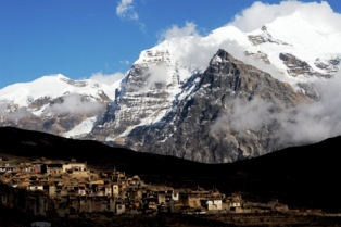
From Naar, our path takes us on to a high plateau that gradually makes its way through prime Snow Leopard country to the end of the Naar Khola Valley. The Naar Phu region is known to have the largest population of Snow Leopard per square kilometer of any in Nepal. Only three hours up from Naar we made camp at 15,190 feet at an area called Naar Phedi. The top of the Kangla Pass is another 3 to 4 hours and 2,240 feet above us. At over 15,000 feet, sleeping can be difficult and our 4am wake up came abruptly. However, an early escape from camp is necessary to give all of us enough time to safely ascend the last 100 to 150 snow-covered meters to the pass. In fact, by the time we arrived at this last push (7:30am) to the large chorten marking the top, the snow was already soft and most of us consistently broke through. This was hard work at 17,000 feet! Our reward for the effort on little sleep? An INCREDIBLE VIEW of the Annapurna Range that few trekkers will ever witness. The scene played out before us stretched from east to west – Lamjung Himal (6988m), Annapurna II (7937m), Annapurna IV (7525m), Annapurna III (7555m), Gangapurna (7454m), Annapurna I (8091m) and beyond to Tilicho Peak and Nilgiri. This magnificent mountain view went a long way to making the 4 hour and 4,900 foot descent to the picturesque village of Ngawal enjoyable. Advil and a good evening meal helped me sleep quite soundly this evening.
After a week of trekking through a remote region where we did not see another group, the walk down to the main Annapurna Trail came as a shock. Not so much because of other fellow trekkers, but rather from the sight of lodges, stores, cafe, bakeries, internet and telephone services. I have to be honest, however, that once we settled in at our camping spot in Manang Village I had no hesitation in joining the others at one of the local cafes for a fresh coffee and chocolate danish. In Manang, I highly recommend a visit to the Manang Vujek Gompa built in the year 1100 by the Lama Kusho Wangyal. This gompa has an outstanding collection of old wall paintings and is open daily from 10am to 6pm.
We now proceeded on the popular Annapurna Circuit and joined other trekkers on the pilgrimage over the Thorong La pass (17,765 feet). The Annapurna and Everest areas of Nepal have the reputation of being crowded and possibly undesirable, but there is a reason these areas are so popular – they are simply beautiful! After many years of trekking in the Himalayas, I am always amazed at how blown away I am every time I visit Nepal. From Manang we made the trek to the traditional camps at Yak Kharka (13,250ft) and then up to Thorong La High Camp at 16,010 feet. Being well acclimatized by this point, we decided to stop for lunch at Thorong Phedi and then continue an hour further up to the High Camp. Again, sleeping this high makes it hard to get a restful night of sleep but we had a 3:30am wake up and it was certainly great to have a shorter day when crossing the pass. It snowed quite a bit today so we were all quite anxious to get up and over the pass as early as possible. The Thorong La pass is a bit higher than the Kangla pass but rather straight forward. The trail up is a series of steps consisting of a moderate climb and then an area of level walking. Many in the group thought these to be false summits but the climbing was rather moderate. The top of the pass is adorned with hundreds of colorful prayer flags and a sign welcoming you to the summit. There was even a small hut where an industrial young local lad was serving hot tea. The new snow from the day before made this morning even more spectacular. The view back to the Annapurna Range was superb! Every good uphill brings with it a very good downhill and it is 4 hours and 5,300 feet down to our camp in the holy town of Muktinath.
The last day on trek was a very pleasant walk gradually down to Jomsom. After a leisurely morning we set out on the “road” passing by and giving a ‘namaste’ to the Hindu pilgrims making their way to the temples in Muktinath. We visited the monasteries at Jharkot and Kagbeni (the gateway to Upper Mustang) before making the windy approach along the riverbed (look out for fossils) to the airstrip village of Jomsom. The next day we were back in the comforts of the Hotel Shanker drinking expresso and eating Indian food by the pool in the gardens.
Like I said earlier on, this trip has it all.
All the Best,
Andy Crisconi
One World Trekking